Exploring the Wild Coastal Trails of the Pacific Northwest
The Pacific Northwest coastline stretches for hundreds of miles across Washington and Oregon, offering a terrain that shifts between dense temperate rainforest, dramatic sea cliffs, and expansive sandy beaches. What makes this region particularly compelling for hikers and nature enthusiasts is the presence of intertidal zones filled with tide pools and the iconic sea stacks that rise from the surf. These landscapes are shaped by powerful ocean forces and volcanic geology, creating a dynamic environment that changes with every tide and season. Walking these trails is not merely a physical activity but an immersion into a living shoreline where each step reveals barnacles, anemones, and the rhythmic pulse of the Pacific.
This article provides an informational overview of what to expect when exploring the coastal trails of Washington and Oregon. It outlines the characteristics of the shoreline environment, discusses navigational aspects of popular routes, and presents considerations for safety and photography that can help individuals plan their own experiences. The intent is to offer context and methodology rather than specific recommendations, allowing readers to make informed decisions based on their own circumstances and preferences. Whether one is a seasoned coastal hiker or a first-time visitor, understanding the interplay of tides, weather, and terrain is essential to a rewarding and responsible outing.
Organizations such as Wild Vistas offer resources that highlight the ecological and recreational value of these shores, but the information here is drawn from general knowledge of the region’s geography and typical conditions. The following sections break down the key elements of coastal trail exploration into manageable topics, each focused on a particular aspect of the experience.
Understanding the Coastal Environment
The shores of Washington and Oregon are part of a geologically active margin where the Juan de Fuca Plate meets the North American Plate. This tectonic setting has produced steep cliffs, folded rock layers, and volcanic headlands that resist erosion in some areas while giving way to softer sediments in others. Sea stacks, such as those found at Cannon Beach or along the Olympic Peninsula, are remnants of headlands that have been isolated by wave action over thousands of years. Their presence creates visual landmarks and provides nesting sites for seabirds, but they also indicate areas where currents and underwater hazards may be present.
Tide pools form in the intertidal zone, the area between high and low tide lines. During low tide, water recedes from rock crevices and depressions, leaving behind small micro-environments that support a variety of marine life. Anemones, sea stars, crabs, mussels, and small fish can be observed in these pools, each species adapted to the challenging conditions of frequent immersion and exposure. The composition of a tide pool depends on factors such as rock type, wave exposure, and the position relative to the tide line. Visitors who take the time to observe quietly often notice the complex interactions between organisms, including predation and symbiosis.
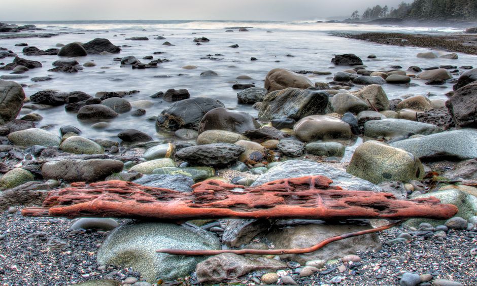
Trail surfaces along the coast vary widely. Some paths follow well-maintained boardwalks through forested headlands, while others descend onto sand or cobble beaches where the route is defined by the shoreline itself. The sandy stretches can be firm or soft depending on recent tides and weather, and large driftwood logs are common obstacles. Sections that traverse rocky headlands may require careful footing on uneven basalt or sandstone. Understanding these conditions helps individuals choose appropriate footwear and pace themselves accordingly.
Navigating Popular Coastal Trails
Washington’s Olympic National Park contains some of the most remote and pristine coastal trails in the contiguous United States. The Ozette Triangle, a three-mile loop that includes a section of beach, offers a moderate hike through forest and along a surf-pounded shoreline. The trail provides access to tide pools at the northern and southern ends of the beach, particularly around Cape Alava and Sand Point. Further south, the Kalaloch area features several short trails that lead to expansive stretches of sand and the Kalaloch Creek sea stacks. Each of these areas has its own tidal schedule, and park information kiosks provide the necessary charts.
In Oregon, the Cape Perpetua Scenic Area near Yachats is a well-known destination for tide pooling and coastal photography. The trail network includes the Captain Cook Trail, which descends to a series of intertidal shelves where spouting horns (blowholes) can be seen during periods of heavy swell. The nearby Thor’s Well, a large sinkhole that appears to drain the ocean, is a popular photographic subject but requires caution due to slippery rocks and unpredictable waves. The Samuel H. Boardman State Scenic Corridor, located near the California border, offers a series of pocket beaches and sea arches accessible via short, steep trails. The diversity of these settings means that no single day of hiking will capture the full range of the region’s coastal forms.
Trail difficulty varies considerably. Some routes, like the beaches of Long Beach Peninsula in Washington, are essentially flat and easy to walk. Others, such as the approach to Hole-in-the-Wall at Rialto Beach, involve navigating loose cobble and logs. Hikers should always check current trail conditions from official land management agencies, as storm damage and winter erosion can alter routes without warning. It is also advisable to start hikes at least two hours before the low tide window to allow time to explore the intertidal zone without being caught by incoming water.
Safety Considerations for Coastal Hiking
Coastal environments in the Pacific Northwest present unique hazards that differ from inland trails. The most critical factor is the tide. Knowledge of tide charts is essential because many trails cross headlands that become impassable during high tide. Even short sections of beach can be cut off by rising water, potentially stranding hikers on a rocky point. Tide predictions are available from NOAA and local visitor centers, and they should be consulted for the specific date and location of any hike. A typical rule of thumb is to begin the return journey at least one hour before the lowest tide begins to rise.
Wet rocks, especially those covered in seaweed or moss, become extremely slippery. Falls on hard basalt can lead to serious injury, and even a twisted ankle in a remote area may require self-rescue. Hikers should wear shoes with substantial tread and consider trekking poles for stability. Close-toed footwear is strongly recommended, as the sharp edges of mussel shells and barnacles can cut skin easily. Additionally, coastal weather changes rapidly; fog, rain, and wind can reduce visibility and lower body temperature. Layered clothing, a waterproof jacket, and a backup navigation device (such as a paper map) are prudent items to carry.
Marine wildlife is another consideration. Seal and sea lion colonies may be encountered on beaches or rocks. It is important to maintain a distance of at least 50 yards to avoid disturbing them, as they are protected under the Marine Mammal Protection Act. Aggression is rare but possible if animals feel threatened. Similarly, jellyfish and stinging creatures may wash ashore; touching them can result in irritation. The best approach is to observe marine life without interfering. If conditions become unsafe—such as a sudden rise in surf height or an approaching storm—turning back or seeking higher ground is a sensible strategy.
Photography Opportunities and Techniques
The interplay of light, water, and rock along the Pacific Northwest coast provides abundant material for photographers of all skill levels. Sea stacks and tide pools are particularly rewarding subjects because they combine texture, color, and reflection. To capture tide pools effectively, a polarizing filter can reduce glare from the water surface and reveal the vibrant hues of anemones and algae. A wide-angle lens allows for compositions that include both the foreground pool and the dramatic backdrop of the ocean and sky. Macro lenses, or close-up filters, enable detailed shots of individual organisms without disturbing them.
Golden hour—the period shortly after sunrise and before sunset—typically produces the most flattering light for coastal photography. The low angle of the sun emphasizes the vertical lines of sea stacks and casts long shadows that add depth to rocky shorelines. On the Oregon coast, morning fog often creates a soft, diffused light that works well for moody images of lone trees or distant stacks. Sunset light, meanwhile, can saturate the layers of rock with warm tones. Checking weather forecasts and sunrise/sunset times helps in planning shoots around optimal conditions.
Long exposures are a common technique for smoothing the motion of waves and creating a silky effect on water. This requires a sturdy tripod and a neutral density filter to reduce light entering the lens. Exposures of several seconds, or even minutes, can transform crashing surf into a mist-like veil. However, long exposures near tide pools require extra caution: salt spray can coat the lens and filter, and a sudden wave surge could soak equipment. Using a waterproof camera bag or rain cover is advisable. Photographers should also be mindful of their surroundings, stepping carefully to avoid damaging fragile organisms or slipping.
Planning a Visit to the Coastal Trails
Seasonal timing affects both the accessibility of trails and the quality of the experience. Summer months (June through September) offer the most reliable weather, with longer daylight hours and generally lower wave energy. However, popular locations can become crowded, especially on weekends. Spring and fall provide milder temperatures and fewer visitors, but they also bring more rain and stronger storms. Winter storms can dramatically reshape beaches and deposit large amounts of driftwood, which may block trail access temporarily. Checking the forecast and any alerts from the local ranger district is a recommended step before departing.
Permits and regulations vary by state and jurisdiction. In Washington, the Olympic National Park requires a wilderness permit for overnight trips, but day hiking does not require one. Oregon state parks and scenic areas typically have parking fees that can be paid at self-service stations or through a day-use pass. Some areas, like the Cape Perpetua Scenic Area, charge a per-vehicle fee. Gathering this information in advance prevents unexpected delays and supports the maintenance of these natural spaces.
Preparation should also include arranging suitable transportation, as many trailheads are located beyond paved roads and may require a vehicle with adequate clearance. Cell phone reception is often limited or nonexistent along the coast, so downloading maps and tide charts before the trip is wise. Carrying extra food, water, and a first-aid kit adds a layer of self-sufficiency. By approaching each outing with an understanding of the environment, its rhythms, and its potential challenges, hikers and photographers can engage with the wild coastal trails of the Pacific Northwest in a way that is both rewarding and respectful.